
‘A JOURNEY BEGINS WITH ONE PAWSTEP!”
October is the ideal time to visit the Southwest with high temperatures ranging from the mid-70’s to mid-80’s, Fall Color at the higher elevation along Hwy 14, and for the most part, and in most places, far fewer people, dogs, and lines than other times of the year.
So, Come along, and travel with us from Lake Oswego, OR to Twin Falls, ID, where we meet up with this trip’s PAWdners, the Gales – Deb, Gil & Luna Dog, from Montana; then head to Southwest Nevada, Southern Utah and Northern AZ for A GRAND LOOP and A GRAND TIME in the Southwest visiting:
Cathedral Gorge State Park in NV; Cedar Breaks National Monument, UT; The Nautilus, Toadstool Hoodoo, and WirePass into Buckskin Gulch Hikes in UT; Glen Canyon, AZ; Horseshoe Bend Overlook, AZ; Monument Valley Tribal Park, UT; Valley of the Gods, UT; Natural Bridges National Monument, UT; the Moki Dugway and Goosenecks State Park, UT; Canyon De Chelly National Monument, AZ; Window Rock Tribal Park, AZ; Petrified Forest National Park, AZ; Route 66, AZ; Walnut Canyon National Monument, AZ; Sedona, AZ; Montezuma Castle National Monument, AZ; Grand Canyon National Park South Rim, AZ; Vermillion Cliffs National Monument, AZ; And, Zion National Park and Kolob Canyon, UT.
DAY 1, Friday, OCTOBER 6, 2023 LAKE OSWEGO, ELKHORN SCENIC BYWAY, BAKER CITY, OR

It’s a sunny day, and we’re “On Our Way” to Baker City, OR, heading out the 84 to Powder, OR, a 4-1/2 hour drive from Lake Oswego, OR, to where we detour, taking the scenic route at exit 285, and follow the ELKHORN SCENIC BYWAY for 106 miles, counter-clockwise, on the 73, the 24, then 7, into BAKER CITY, OR.
ELKHORN SCENICE BYWAY

Wallowa-Whitman National Forest

Baker Valley Overlook

Anthony Lake & Anthony Lake Day Use & Picnic Area
at 7,100′
(See Map Below)
NWFS PASS, AMERICA THE BEAUTIFUL PASS or FEE REQUIRED (Placed in Envelope)
Note: There is a .8 mile Lake Shoreline Trail around the Lake Here, as well as other hiking trails.
Anthony Lake
Map

(For you Photo Hounds: These photos were taken on the shore below the Anthony Lake Day Use & Picnic Area)
 ‘Gold Rush’ of
Larch and Lodgepole Pine, in the Elkhorn Range of the Blue Mountains…

 …arriving in Baker City at 3:00 p.m. (Pacific Time). We check in to our motor lodge, the BRIDGESTREET INN, then, walk across the street and follow the…
Leo Adler Parkway Path

… along the Powder River, into town for a Bite to eat at the Dog Friendly, YUM:
AJ’S CORNER BRICK BAR & GRILL
Baker City, OR

OVERNIGHT: BRIDGE STREET INN, Baker City, OR
(Note: There is a Spacious Pet Relief Area behind the hotel with a bright security light that comes on when it’s dark!)

AND, WE’RE OFF TO GREAT PLACES!
On our first day, we have driven 397 miles, taken 3,256 Pawsteps,
all while enjoying a 75 degree H temp.
DAY 2, Saturday, OCTOBER 7, 2023 BAKER CITY OR, THOUSAND SPRINGS STATE PARK and SCENIC BYWAY ID and TWIN FALLS ID
“It’s a New Dawn, It’s a New Day…and We’re feeling good” at 8 a.m., and 47 degrees, as we leave Baker City, east on the 84 for THOUSAND SPRINGS STATE PARK, ID, a 3 hour drive.
…At MP 147, 1.5 hours south of Boise, we exit at Malad Gorge State Park, the first of 4 stops we’re making today on our detour to TWIN FALLS, ID at:
TIDBITS:
- Thousand Springs State Park is composed of five units
- This area is called the “Magic Valley”
DOGS: Here’s the Scoop!
- Dogs allowed on leash
STATE PARK PASS or FEE (Cash in Envelope) REQUIRED.
Note: This Fee/Pass is good at all ID State Parks on Same day.
Thousand Springs State Park
Map

Malad Gorge State Park
2,800′
Our first stop in Thousand Springs State Park is Malad Gorge so we pay our State Park Fee here: placing $7.00 (Cash Only) in an Envelope, and display the permit on our dashboard

Note: When we enter the park, we stay right for “Devil’s Washbowl;” park; then follow the paved .6 mile RT path Across the Bridge, and along the 250′ deep Gorge…

…to the end, and viewpoint, where we look downriver, see one waterfall, then look back under the bridge, and there is the…

60′ Devil’s Wash Bowl Falls

Then we’re on to our Next stop, Ritter Island, following signs to Hagerman, using GPS, and taking a series of country roads, until we see the can’t miss sign for “Ritter Island,” and down the steep, narrow, gravel road we go, (pulling over for a quick photo op when we see Lemon Falls cascading over the cliff on our left)….
Ritter Island
 …then continuing down to where other cars are parked, we take a short walk to our left along the road, another short trail to the left, and, Voila, we are at the base of Lemon Falls!

Our Next stop, Box Canyon Springs, is only a few miles away…We spot a small sign that says “Box Canyon.” so take a right, driving past the first parking lot, to the larger paved parking lot in back. And, From here it’s only a short distance to the overlook above this 200′ deep Canyon and stunning view of the Emerald Pools below.
Note: There is a hiking trail here that you can take down to a waterfall and bottom of the canyon.
Box Canyon Springs


Our Last stop is Niagara Springs, a few miles further, and once again we drive down a steep unpaved road to the bottom, then take the paved road, along the cliff, and pull over when we see the Springs tumbling down the hillside (at 250 cu feet per second); park; and walk up to the viewing platform (Note: there are both stairs and a ramp)
Niagra Springs


Well, that put a SPRING in FLYNNN’s step (ha! ha!)
Time to hit the road for Twin Falls, where at 4 pm, (Mountain Time) we check into our MY PLACE HOTEL Room, and wait for our friends The Gale’s from Montana to join us!
OVERNIGHT: MYPLACE HOTEL, Twin Falls ID
FLYNN Breck Checking In!
Loving the Spacious room with stove top, and full size refrigerator

THOUSAND SPRINGS STATE PARK
A HIDDEN GEM OFF THE 84!!!
That’s a total of 272 miles, 10,121 Pawsteps,
and a 75 degree High Temp for the FLYNN DOG today!
DAY 3, Sunday, OCTOBER 8, 2023 TWIN FALLS ID, CATHEDRAL GORGE STATE PARK NV, CEDAR CITY UT
Boy, it’s impossible to keep track of all the Time Zone Changes today, as we start out in Mountain Time, then Pacific Time, and back to Mountain Time, from TWIN FALLS, ID to CATHEDRAL GORGE STATE PARK, NV ending in CEDAR CITY, UT.
This morning we’re in a caravan with the Gales, traveling on the long, lonely stretch of Hwy 93 South, aka,The Great Basin Hwy, for 369 miles and 5-hours, at an elevation of over 5,000′ to…

CATHEDRAL GORGE STATE PARK, NV,

TIDBITS:
- Close to 2,000 Acres of Land
- One of Nevada’s first State Parks
- There are 6 developed trails
DOGS: Here’s the Scoop!
- Dogs must be kept on a leash of not more than 6′ in length
PERMIT OR FEE REQUIRED. Pay with Credit Card at Machine along the road inside the park (just past the Visitor’s Center turnoff)
Cathedral Gorge State Park
Map

At 2:00 p.m. it’s a warm 80 degrees, but, we quickly forget the Heat when we feast our eyes on the Gorge. What a Sight!
After our long drive, we first make a beeline to the visitors center for a pitstop.
Then, it’s back out to the main road, a stop at the Pay Station, then we drive the short distance to the Slot Canyons, pulling off in the parking areas, one after the other, for Moon Caves, then Canyon Caves and Cathedral Caves Slot Canyons,
Moon, Canyon and Cathedral Caves
Slot Canyons
COOL!
(And We kid you not, from the moment we enter the slot canyons there is a noticeable drop in temperature, and welcome relief from the heat.)


From the Slot Canyons, we drive on, staying to the right, park in the Day Use Picnic Area, then hike the trail to Miller Point for 2-miles RT – through the now shaded Gorge (thanks to the late afternoon sun sinking in the West,) across a footbridge, and up the stairs to Miller Point. All while, the FLYNN Dog and LUNA go: “PANT! PANT! PANT!”
Miller Point Hike
2-Miles RT


After 3-hours of exploring, we’re ready for the final 1-1/2 hour push to CEDAR CITY, UT, taking the 319/56 East….
…where we check into our hotel, then head out for dinner at the Dog Friendly:
CENTRO WOODFIRED PIZZA
Cedar City, UT
(Note: The Streetside tables pictured are dog friendly, but tonight is bit chilly,
so we eat inside while the dogs hang out in our cars)

OVERNIGHT: QUALITY INN, Cedar City, UT
AND WE’VE ONLY JUST BEGUN!
WHOA FLYNN and LUNA clocked 455 miles, and took 6,888 Pawsteps,
with an 80 degree High temp at Cathedral Gorge State Park
DAY 4, Monday, OCTOBER 9, 2023 CEDAR CITY UT, HWY 14/MARKAGUNT HIGH PLATEAU SCENIC BYWAY, CEDAR BREAKS NATIONAL MONUMENT, NATULIUS HIKE, TOADSTOOL HOODOOS HIKE, WAHWEAP OVERLOOK, GLEN CANYON BRIDGE, PAGE AZ
On the Map below, first locate Cedar City, UT on the Left along Hwy 15, then follow Hwy 14 East, to the 89 South, and east to Page, AZ, and you have today’s route.

Autumn is at it’s peak (Ha, Ha) along Hwy 14, aka the:
MARKAGUANT HIGH PLATEAU SCENIC BYWAY
..and our Jaws Drop as all of a sudden find ourselves embraced in the narrow Red Cedar Canyon.

First stop along the Byway, is a large unmarked pullout on the right for: (where we see a number of cars pulled over)
ZION OVERLOOK

…then we continue on Hwy 14, take a left onto Hwy 143 and into:
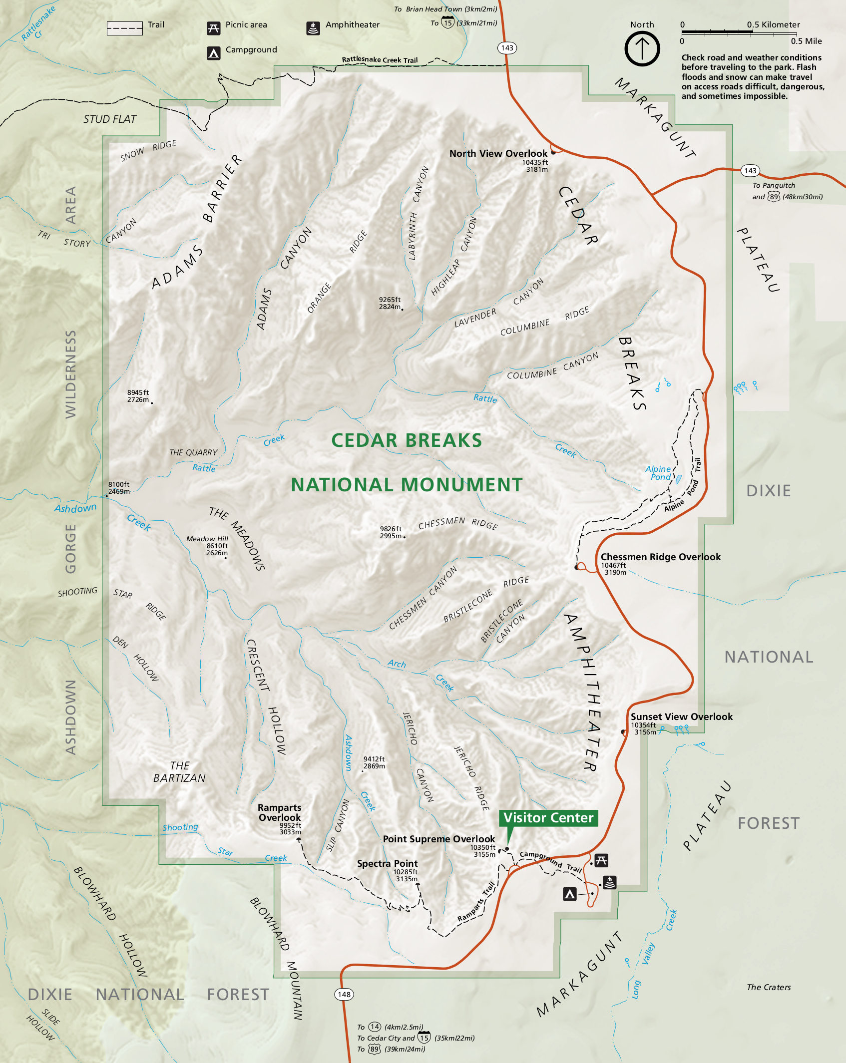
CEDAR BREAKS NATIONAL MONUMENT

TIDBITS:
- Located on the Western Edge of the Colorado Plateau at top of the “Grand Staircase”
- 6,155 Acres, dedicated as a National Monument by FDR in 1933
- elevation, 10,000′
- Massive Amphitheater – Viewed from the various overlooks
- Reminiscent of Bryce Canyon
DOGS: Here’s the Scoop!
- Dogs are allowed on paved areas including parking lots and scenic overlooks, as well as the Sunset Trail
- Dogs must be on a leash no longer than 6′
- Pet Owners must pick up after their pets and dispose of waste in a trash receptacle
AMERICA THE BEAUTIFUL PASS OR FEE REQUIRED. Shown or Purchased at Visitor’s Center
…At the Visitor’s Center, We stop to show our Pass, and pick up a Map, before taking this 10-mile RT drive (out and back) to the Sunset View, Chessman Ridge and North View Overlooks.
Cedar Breaks National Monument
Map

Sunset View Overlook


Chessmen Rige Overlook


North View Overlook


Then Back on Hwy 14, our adventure continues east, pulling out for one last photo when we see the Golden Aspens set against the Turquoise Waters of…
NAVAJO LAKE
Dixie National Forest
3-miles L, .5-miles W, Maximum Depth 25′, Elevation 2,754′
“It’s a Stunner!”


And, it’s out to the 89, we find a gas station, fill up, and continue through Kanab UT, East, until we see the “Paria Ranger Station and White House Campground,” turnoff on our right; take the undeveloped road toward the campground, over the first wash, a second wash, then park on top of the rise, and walk back down to the wash, where at 4:30 p.m., we are now off on…

THE NAUTILUS HIKE
.9 miles RT
(Note: there’ are no signs that say Nautilus)
BLM LAND. NO FEE
(Note Upper PawPrint for approximate Trailhead Location)

…keeping our eyes peeled to the right for what resembles a bird print in the side of the rock. Find it! And, Enter,” the Nautilus”…Scramble up through the slippery spiral…and stand on top of this nifty seashell formation.


…Then, it’s back to the 89E, and 6 minutes further, when we see the Can’t Miss Sign on our left for:

Toadstool Hoodoos Hike
Map
1.8 mile RT Hike
NO FEE

The time is 5:00 p.m., and we happily walk along the now shaded trail (thanks once again, to the sun going down) to the TOADSTOOLS!


And, We Enter the….
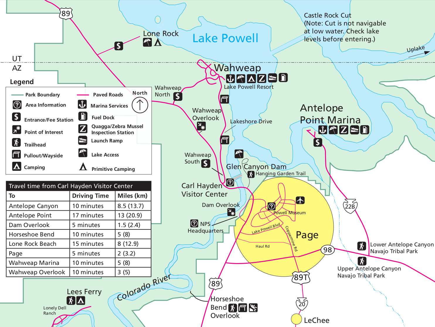
GLEN CANYON NATIONAL RECREATION AREA

Glen Canyon Recreation Area
Map
 …where at 7:00 p.m., when we see the sign for “Wahwheap Overlook,” we take a left uphill, arriving just in time for Twilight, over Wahweap Bay on Lake Powell.
WAHWHEAP OVERLOOK AZ,

Last stop, GLEN CANYON BRIDGE which we cross, pull over to our right, then walk back onto the Bridge to look down into Glen Canyon at the Colorado River….

After a long, but rewarding day we reach Page, AZ, check into our hotel, and at 7:30 pm (AZ time) go in search oft:
FIESTA MEXICANA, Page AZ
Note: The Covered Front Porch (pictured) is Dog Friendly, but at 7:30 p.m. it once again is a little chilly to sit outside, so the pups stay in our Cars.

OVERNIGHT (for the next 2 nights:) LA QUINTA, Page AZ.
3rd Floor Room, Whoo Hoo, Elevator Ride!
(Note: No there is not a Real Pet Relief Area…just lots of rocks, so we walk and find some sand)
FLYNN Cozy!

WHAT A GLORIOUS DAY!
Let’s hear it for, 178 miles, 12,631 PawSteps, and Temps in the low to mid 80’s
DAY 5 Tuesday, OCTOBER 10, 2023 PAGE AZ, WIREPASS TO BUCKSKIN GULCH, UT HIKE PAGE, AZ
Today, we’re headed back the way we came, on the 89, this time west for about an hour to The Cockscomb turnoff on the left, and WIREPASS TO BUCKSKIN GULCH HIKE…
PERMIT REQUIRED. Note: you’ll want to go to REC.GOV and purchase your permit in advance. The Day Use fee at this writing Is $6/per person and $6/per dog (add dog(s) under number of children)..and Print your permit out to display on your dashboard.
(Note Lower Pawprint on Map Below for TH Location)
The Road to the Trailhead is BUMPY, a washboard for 8.4 miles 1-way, I kid you not, full of ruts, rocks, and you name it ….And, As for the Parking Lot? It’s packed, since it shares the parking for the Popular “WAVE Hike” (Note: The Wave Hike requires entering a Lottery for a Special Permit.)

At 1:30 p.m., we begin our 4.4 mile RT WIREPASS/BUCKSKIN GULCH HIKE across from the Parking Lot, walking up the exposed wash, in the heat of the day! (Note: The Warning Sign for Flash Flooding, and pay heed! It’s NO JOKE) to the…


… WirePass Slot Canyon entrance. Here we take the “dog friendly” detour to the right, up, around, and down the Slickrock Slope (What is Slickrock you ask? Slickrock is a Sandstone with surface similar to 100-120 grit sandpaper)…
Down the Slickrock we Go!
Notice the “CAROLE METHOD” on this uncertain terrain

…and into the slot canyon for our second challenge, two narrow 4′ drops! “ASSISTANCE PLEASE!” And, Gil comes to the rescue assisting all of us (furry too!). Then through the Slot Canyon…
WirePass Slot Canyon


…And, it’s not long before we Exit into the Open, and go right

… Into Buckskin Gulch, hiking for about a mile, one-way, until we reach a large pool of water covering the trail, so turn around and head back…
Buckskin Gulch
(Note: The entire Buckskin Gulch Trail is 23.6-miles long)

 Can you Find Flynnie?


…. back through the WirePass Slot, up the 4′ drops, up the Slickrock Slope (Notice,The Flynn Method!,) out of the Slot Canyon…and back to our cars!
“What’s taking you so long?”

What an Amazing Hike! And, at the end of the day, FLYNN is One Happy Pup…
Joy Riding!

OVERNIGHT: LA QUINTA, Page AZ
Snooze!

A 5 STAR DAY INDEED!
…with, Yay!, only 88 miles, 15,267 PawSteps,
and 85 degree H temperature,
at an Elevation of 4,450′
Other Nearby Drives & Hikes:
The “New Wave” – 1.25 Loop. No Fees. Off Hwy 89
Secret Arch – Behind the Shell Gas Station in Page
Cottonwood Canyon Rd.
Grosvenor Arch
Kodachrome Basin
Paria Canyon from Whitehouse Campground
DAY 6, Wednesday, OCTOBER 11, 2023 PAGE AZ, HORSESHOE BEND, MONUMENT VALLEY UT, KAYENTA AZ
Today, we’re on our way to Monument Valley, taking the 89S out of Page to HORSESHOE BEND, AZ, then back to the 98E to the 160N and Kayenta, AZ, 163N to MONUMENT VALLEY, UT, then back on 163S to Kayenta, AZ, and our dog friendly lodging.
From Page, AZ, It’s only a few minutes drive south on the 89 to the can’t Miss GIANT Sign on our right for:
 We pull in, pay our $10 fee to the Booth Attendant, park in the large paved tourist parking lot, then join the masses for a 1.5 miles RT walk down and back on the hardened path to the Canyon Rim and Overlook above HORSESHOE BEND in the Colorado River… CROWDED!
DOGS: Here’s the Scoop!
- Pet’s must be on a Leash no more than 6′
PAY FEE to BOOTH ATTENDANT
HORSESHOE BEND
(an Incised Meander in the Colorado River)

“FLYNN is one Lucky Dog!”
(Ha! Ha! Horseshoe Bend, Get it?)


From Horseshoe Bend, we head back to the 98E, take the 160N through Kayenta, then 163N, and 2-hours later join the short (emphasis on short) line of cars entering the NAVAJOLANDS:
MONUMENT VALLEY TRIBAL PARK
“Where the Earth Meets the Sky”
The attendant takes our fee, and our first stop is the large paved Visitor’s Center Parking Lot, where we walk along the sidewalk looking at Monument Valley Below …
TIDBITS:
- Monument Valley sits 5,564′ above sea level
- The Park extends into AZ & UT covering approximately 91,696 acres
- John Wayne called Monument Valley “God’s Treasure”
- The Mountains range from 100′-1,500′ tall
- Established in 1958 by the Navajo Nation as a Preserved Environment
DOGS: Here’s the Scoop!
- Pet’s must be Leashed
- Dogs are Welcome at Pullouts on Scenic Drive
- Dogs are Allowed on 4-mile RT Wildcat Trail
ENTRANCE FEE: Pay Fee to Attendant at toll booth, Credit Card Only.
Monument Valley Tribal Park
Map

 After our PAWSTRETCH, we get back in our cars, and drive down into the Valley (“down in the valley, valley so low”,) and begin our 17-mile Scenic Drive through this Magnificent Navajo Valley of Butte’s, Mesa’s, and Spire Formations.
East Mitten & Merrick Butte
 Elephant Butte
There’s a Dust Storm A’blowin’

Totem Pole & Yei Bi Chei

Navajo Code Talker Outpost


Wild Horses in the Valley

The Three Sisters

John Ford’s Point
Drive-In Movie Anyone?

Camel Butte
 2-1/2 hour’s later, we drive back up to the Visitor’s Center Parking Lot, park, then walk back to the Dog Friendly Wildcat Trail, located just to the left of the road we took down into the Valley.
(Note: FLYNN and Carole do only do 1.5 RT of this 4-mile RT hike while the Gales Hike the entire trail.)
Wildcat Trail

Sentinel Mesa & The Mittens
from the Trail

OVERNIGHT (for the next 2 nights:) MONUMENT VALLEY INN, Kayenta, AZ (Note: We Booked our hotel on Hotels.com for the Best Rate)
Note:
- One of 2 Dog Friendly hotels in this area
- Our room was Clean, Comfortable, “Bare Bones” (and, while we had a small refrigerator and microwave, our friend’s room did not, and they were told the other rooms did not have these amenities)
- No WiFi
- No Pet Relief Area (other than rocks)

MONUMENTAL DAY!
Hooray for Hollywood with only 166 miles, 11,091 PawSteps,
at an Elevation ranging from 5,000-6,000′, and Ideal Temps in the 70’s
DAY 7, Thursday, OCTOBER 12, 2023. KAYENTA AZ, MEXICAN HAT UT, VALLEY OF THE GODS UT, MOKI DUGWAY UT, NATURAL BRIDGES NATIONAL MONUMENT UT, GOOSENECK STATE PARK UT, FOREST GUMP HILL UT, KAYENTA AZ
Today We’re off exploring BEARS EARS NATIONAL MONUMENT…from Kayenta, we drive past Monument Valley, and continue on the 163 to just outside the town of Mexican Hat to view the MEXICAN HAT formation, then turn left driving through VALLEY OF THE GODS, a right up the MOKI DUGWAY/ 261 North, along the 95 W and 275 into NATURAL BRIDGES NATIONAL MONUMENT, then an about face on the 261 to the 316, a right into GOOSENECK STATE PARK, back out to the 261, FOREST GUMP VIEWPOINT, the 163, and back to Kayenta, AZ
Note: Last Gas Stop MEXICAN HAT!
BEARS EARS NATIONAL MONUMENT
MAP

…And, We’re on the 163, driving through and just a little ways past the town of Mexican Hat, to a dirt road on our right that leads to a campground, but before we reach the campground, we pull over and take photos these photos of:
MEXICAN HAT FORMATION


Then, A few miles further on the 163, we see a small sign for “Valley of the Gods,” and take a left following the well graded road for 17 scenic miles through the VALLEY OF THE GODS (BLM) (AKA, Mini Monument Valley,) past the impressive Buttes and Rock Formations in this Valley…
DOGS: Here’s the Scoop
- Dogs are allowed on BLM Land so you’re free to get out of the car and roam
NO FEE
VALLEY OF THE GODS


When we exit Valley of the Gods, we take a right, and have a BIG “UH OH” Moment, Panic sets in, when we realize there’s No turning back now, we’re driving up the narrow, unpaved, Death Defying, “One of Utah’s most Dangerous Roads,” rising steeply for 3 terrifying miles, the:
MOKI DUGWAY
(Meaning: Roadway Carved into a hillside or mountain)
YIKES! Look Out Below!

When we reach the top, we take a moment, Breath a Sigh of Relief, happy to be back on firm ground, then continue on along the now paved Hwy 261, to the 95, 275, and into:
NATURAL BRIDGES NATIONAL MONUMENT

TIDBITS:
- 1908 President Theodore Roosevelt proclaimed Natural Bridges a National Monument, creating Utah’s first National Park System Area.
- the 3 bridges are the result of water sculpting the stone
- The bridges have had several names, but the General Land Office used the Hopi Names when the Park was enlarged in 1909 to protect the nearby Puebloian Structures.
DOGS: Here’s the Scoop!
- Dogs are allowed on all parks roads and parking areas
- in the campground
- on paved paths to bridge viewpoints
- at paved pullouts along the scenic drive
- at picnic areas
- Dogs must be on leashes, 6′ long maximum
- Please pick up after your pet
- Dogs are not allowed on any hiking trails, anywhere off-trails or in the visitor’s center
AMERICAN THE BEAUTIFUL PASS OR FEE REQUIRED, Shown or paid at Visitor’s Center.
Natural Bridges National Monument
Map

…After checking in at the Visitors Center.. we begin the 9-mile paved loop…
 …stopping at:
Sipapu (“Place of Emergence”) Bridge Viewpoint
220′ H, 268′ Span, 31’W, 53′ thick
4th longest Natural Arch Bridge in the World

Kachina (Spirits) Bridge Viewpoint
210’H, 204′ Span, 44’W, 93′ Thick

…and…
Owachomo (Hopi for Rock Mound) Bridge Viewpoint
106’H, 180′ Span, 27’W, 9′ Thick

Then it’s back the way we came, and there’s No escaping the dreaded MOKI DUGWAY, so, down we go…

…at the bottom we continue straight ahead on the now paved 261 until we reach the 316, take a right and drive into:
GOOSENECKS STATE PARK, UT
on the San Juan River
TIDBITS:
- One of the most distinct Incised Meanders in the US
- With 3 Bends in the River
- San Juan River is 1,100′ below the overlook
- Canyon Walls are made from Shale and Limestone
PASS OR FEE PAID TO ATTENDANT AT TOLL BOOTH or MACHINE, if attendant not present.
A short walk from the Parking Area and we look down at the GOOSENECKS!


From here, we’re on our way back to Kayenta, taking the 261, onto the 163, with one last stop for FLYNN’s:
Forest Gump Moment
on
FOREST GUMP HILL

OVERNIGHT: MONUMENT VALLEY INN, Kayenta, AZ
”LIFE IS JUST A BOX OF BISCUITS
AND, THAT’S ALL FLYNN HAS TO SAY ABOUT THAT!”
Today we drove 207 miles, clocked 3,234 PawSteps, Temps in the mid-high 50’s, and Elevation ranging from 1,600′-6,500′
DAY 8, Friday, OCTOBER 13, 2023. KAYENTA AZ, CANYON DE CHELLY NATIONAL MONUMENT, WINDOW ROCK AZ
Today starts the 2nd week of our Southwest PawTrip at 6:30 a.m. with a 35 degree temperature, in Kayenta…Brrr Chilly Morning! Back to Bed!
At 8 a.m. we’re all packed up, and on our way, after gassing up, for CANYON DE CHELLY, an hour’s drive from Kayenta taking the 163 to the 160, then 59.
CANYON DE CHELLY
“Tsegi” (Say-ih)

TIDBITS:
- Established as a National Monument in 1931 to preserve the record of Human History
- People have lived in the Canyon for nearly 5,000 years
- Canyon is home to the Navajo People
- Canyon Walls stand over 1,000′
- Canyon De Chelly then and now is an Epicenter of Navajo Culture
- North Rim Drive its 35-miles RT, opportunity to see Cliff Dwellings
- South Rim Drive is 37-miles RT, featuring Spider & Face Rocks
DOGS: Here’s the Scoop!
- Pets on Leash are welcome at the overlooks (including slickrock) and in the campground
- Pets are not permitted in the Welcome Center, on canyon tours or White House Trail
NO FEE
Note: We took the advice of those who have gone before, and drive the North Rim in the morning, and South Rim in the Afternoon for the best lighting. You’ll also want to get out your binoculars and/or use your telephoto lens for this adventure.
Canyon De Chelly
Map

North Rim
Antelope House Overlooknn & Ruin

North Rim
Mummy Cave Ruins & the Canyon Floor

North Rim
Massacre Cave

South Rim
Spider Rock (is a Sandstone Spire that Rises Over 800′ from Canyon Floor) &
Face Rock

South Rim
Tsegi Overlook

Now from Canyon De Chelly to Window Rock, the Navajo Nation Capital, we Go!
OVERNIGHT: QUALITY INN, Window Rock AZ
 And, When we check-in, we’re given this Special Welcome:

LET’S HEAR IT FOR
205 miles, 6,898 PawSteps, 6,109′ elevation, and a pleasant 66 degrees H temp
DAY 9, Saturday OCTOBER 14, 2023 WINDOW ROCK AZ, WINDOW ROCK TRIBAL PARK, PETRIFIED FOREST NATIONAL PARK, ROUTE 66/HWY 40, WALNUT CANYON NATIONAL MONUMENT, SEDONA AZ
Today is the Solar Eclipse, and sacred day to the Navajo Nation who observe this Occurrence by staying indoors with curtains drawn.
We, however, are moving on, starting our day at the WINDOW ROCK TRIBAL PARK, then visiting the PETRIFIED FOREST NATIONAL PARK, Hunting for OLD ROUTE 66 ATTRACTIONS off Hwy 40 and paying a visit to WALNUT CANYON NATIONAL MONUMENT, then making our way to SEDONA, AZ.
From our hotel we take Navajo Route 12 a short distance to Window Rock Blvd, ending at…
WINDOW ROCK TRIBAL PARK
(Window Rock & Code Talker Memorial)


From here, it’s out to Hwy 40W, where in little over an hour, we turn right into the:
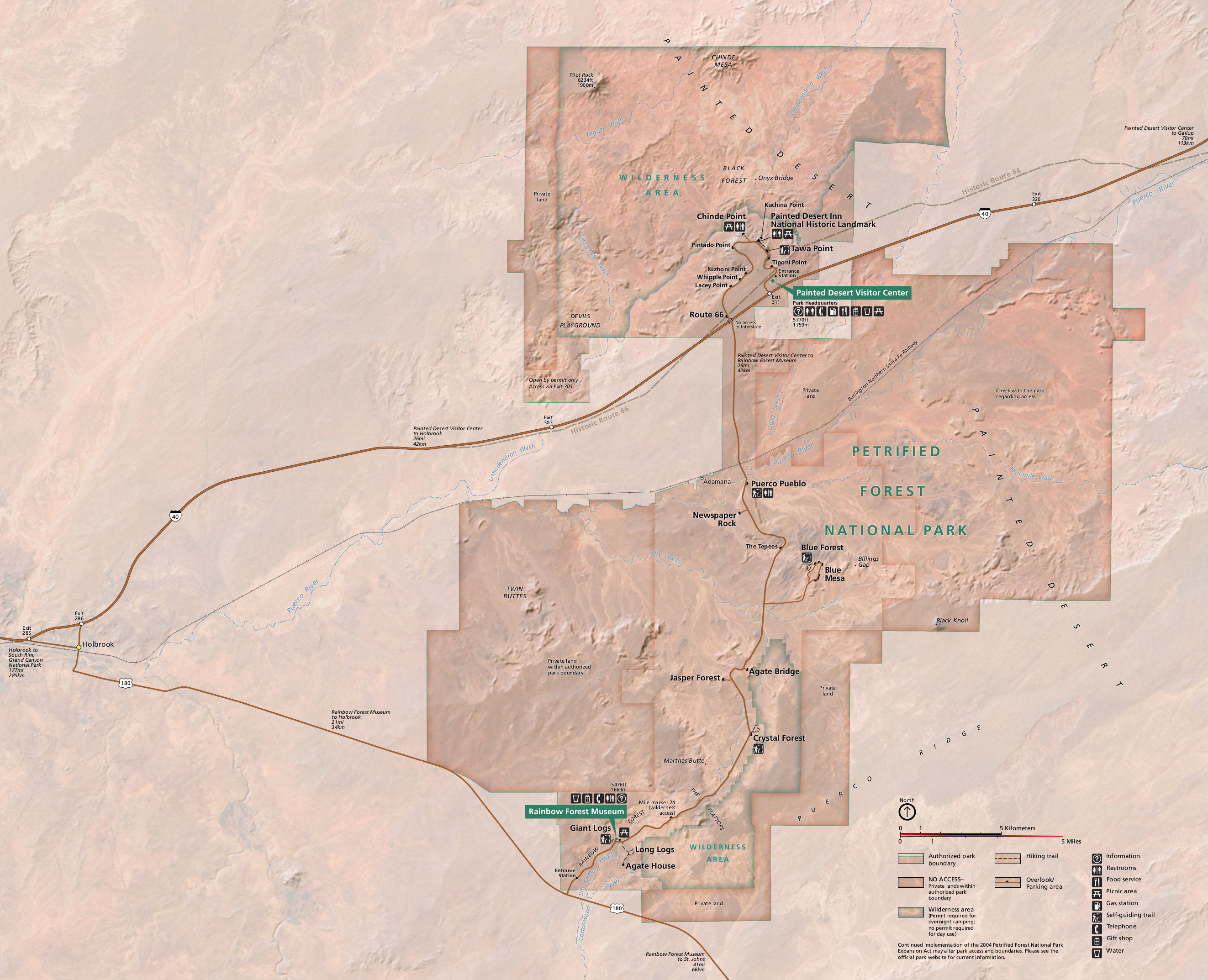
PETRIFIED FOREST NATIONAL PARK

TIDBITS:
- Created in 1906 by Teddy Roosevelt
- Designated a National Park in 1962
- 221,390 acres
- Only National Park that contains a segment of the Old Route 66
- Petrified Forest is one of the most continuous sections of Triassic-aged rocks in the world
DOGS: Here’s the Scoop!
- Dogs are allowed on any paved road or trail, as well as, designated Wilderness Area in Park
- Pick Up After Pet
- Keep Pet on a leash 6′ or less
- Keep Pets at a respectful distance from Wildlife
- Dogs are not allowed in Park Buildings
- Do not leave your Dog unattended in vehicle
- BARK RANGER PROGRAM Here
- And on this occasion pick up solar eclipse viewing glasses
AMERICA THE BEAUTIFUL PASS OR FEE REQUIRED
Petrified Forest National Park
Map

….And, we Stop at the Visitor’s Center to pick up a Park Map, our Solar Glasses and…
FLYNN’S first “Bark Ranger” Loot

…then, drive on to Kachina Point, just in time for the Solar Eclipse
Painted Desert


…We make several more stops at the various viewpoints overlooking the Painted Desert, then cross under the Hwy, and turn left up the hill to the Dog Friendly paved..
Blue Mesa Trail
Paved 1-Mile RT


Back to the main road, another left, and we check out the petrified logs on the paved DOG FRIENDLY:
Crystal Forest
Paved .75 Mile Loop


Note: There are other DOG FRIENDLY trails, but we decide to exit the South Entrance of the Park, and continue North on the 180 to Holbrook:
“Come on DOGGIES Let the Good Times Roll on AZ ROUTE 66!”
Along HWY 40 W we exit at (towns) to find the KITSCH on the AZ Section of ROUTE 66
from The Petrified Forest National Park to Winona


We start in the:
Petrified Forest National Park
(on the right just before crossing under Hwy 40)

then…
Holbrook, AZ
(Rainbow Rock Shop, 101 Navajo Blvd/180)

Jack Rabbit Trading Post
Exit 269, Joseph, AZ

“Standin’ on the Corner in Winslow Arizona”
Exits 252,253, 255, Winslow, AZ
(Kinsley & E 2nd Street)


…And, lastly the…
Double Arrow
(Which is Now Just 1 Arrow)
Exit 219

Well, That Was Certainly Fun! But, now we need to hoof it if we want to make it before closing to:
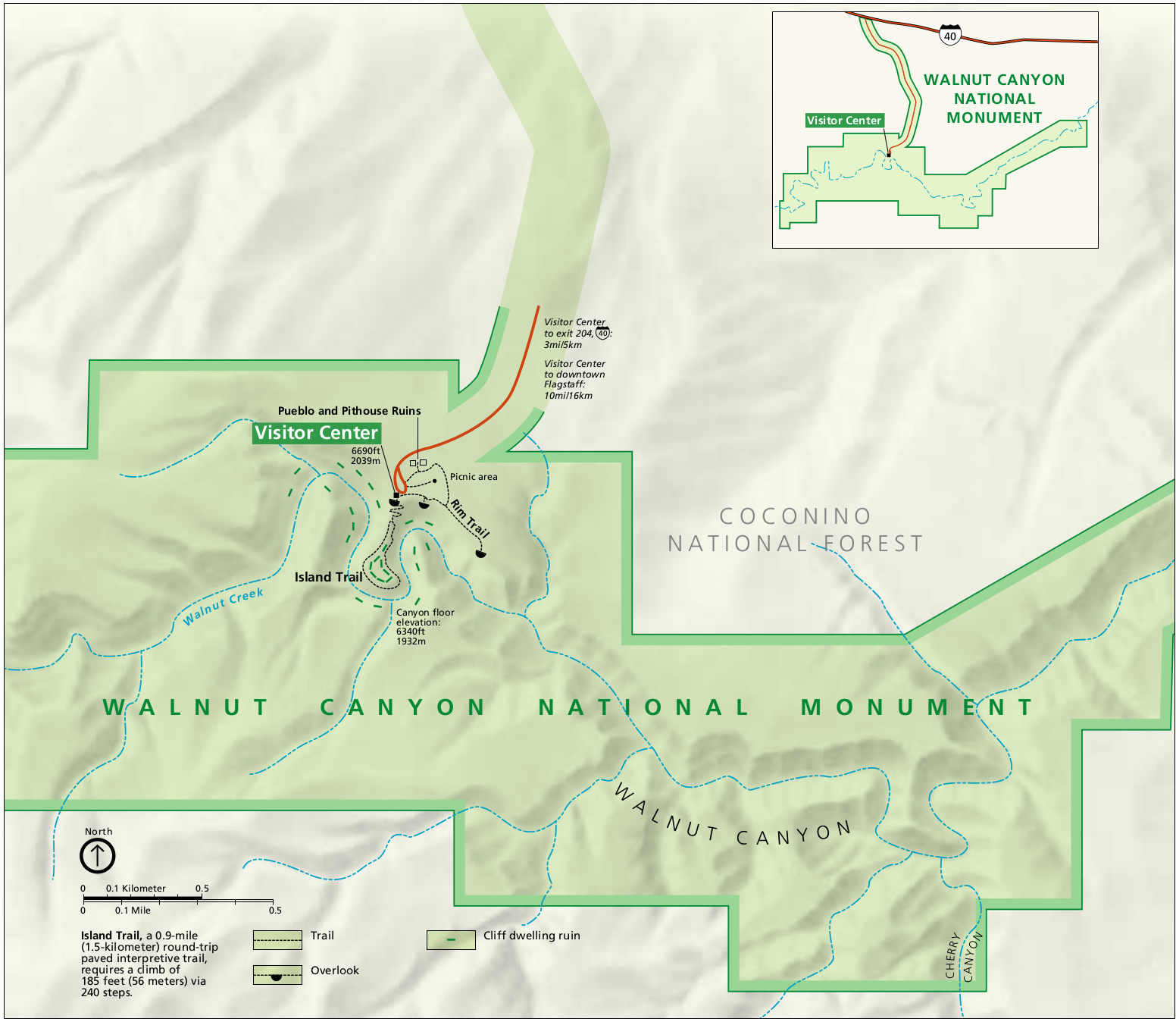
WALNUT CANYON NATIONAL MONUMENT
TIDBITS:
- Cliff Dwellings more than 800 years ago
- Rim Trail passes the ruins of rimtop structures
- Walnut Canyon is 20 miles in length and 400′ deep
- The Top of the Canyon Plantlife is Sonoran, while the lower part is Riparian
DOGS: Here’s the Scoop!
- Dogs are allowed on the Paved Rim Trail.
- Dogs are not allowed on the trails below the Rim.
- Pick up after pup
- Use Leash
AMERICA THE BEAUTIFUL PASS OR FEE REQUIRED
Walnut Canyon National Monument
Map

Phew, and we make it just in time to walk the Dog Friendly:
Rim Trail
Paved .7 RT
(You’ll definitely need binoculars in order to see these ruins/cliff dwellings from the trail)

Our day comes to an end as we head through Oak Creek Canyon/89A, for Sedona,
The main drag is busy with tourists, and there’s no getting around it, so we are patient, and eventually reach our hotel at the other end of town, happy to discover we’re away from all the crowd.
OVERNIGHT: ARROYO PINION HOTEL – 3119 State Route 89a, Sedona AZ
Check Out the FLYNN Pad! Can you say Upgrade?

TODAY WE ROCKED AND ROLLED!
for 246 miles, 12,399 PawSteps, at an average elevation of 5,400′,
with ideal temps in the 60’s-70’s
DAY 10, Sunday OCTOBER 15, 2023 SEDONA AZ. LAYOVER DAY
YIPEE! It’s LAYOVER DAY, and We’re on our own to lounge away the morning in our room, that is, until we decide to explore and take the RED ROCK LOOP and BOYNTON CANYON Scenic Drives to see the sights.
(from the “Experience Sedona” Brochure)
Here’s the Map

…Our First drive is the 13-mile:
RED ROCK LOOP
from Lower Red Rock Drive to Upper Red Rock Drive where we have great views of Courthouse Butte, Bell Rock and Cathedral Rock

…then we head across the main road and take the 11-mile RT (out and back) Drive on:
DRY CREEK ROAD TO BOYNTON CANYON


LAYOVER, LAYOVER, RAH, RAH, RAH
ALL IN A SCENIC DAY’S DRIVE
for only 23 miles, 2,984 PawSteps, with an 86 degree H Temp
DAY 11, Monday OCTOBER 16, 2023 SEDONA AZ, MONTEZUMA’S CASTLE NATIONAL MONUMENT, GRAND CANYON NATIONAL PARK AZ
Today, we are All Rested Up, and Ready to make our way to the Grand Canyon National Park South Rim, with sidetrips to see Chapel of the Holy Cross, and visit Montezuma Castle National Monument.
We pack up and leave Sedona, taking the 179 out of town, and turning left on Chapel Road, pulling in across the street, where we take this picture of the Famous and Impressive:
CHAPEL OF THE HOLY CROSS

…then continue out to the 17 south, taking exit 289 to:
MONTEZUMA CASTLE NATIONAL MONUMENT
Montezuma Castle National Monument
Highway Map

TIDBITS:
- Established in 1906
- The 3rd National Monument dedicated to preserving Native American Culture
- Cliff Dwelling: 20 Room High Rise Apartment nestled in a Limestone Cliff
DOGS: Here’s the Scoop!
- Dogs allowed on Leash
- Pick up After Dog and Dispose in provided refuse containers
- Do Not Leave Pets in your car
- Pets are not allowed in the Visitor’s Center and Restrooms
- BARK Ranger Program
FLYNN’S Bark Ranger Loot

Paved .4 mile Loop Trail


Now it’s Time to head for the Grand Canyon, so we take the 17 North to Flagstaff, 180 to the 64N to the Grand Canyon National Park South Rim Entrance.

BUT, WAIT! When we come across this GIANT FRED FLYNTSTONE on the side of Hwy 64, We have to stop for a photo with Fred and the FLYNSTER!…This is a photo op too good to pass up!
”FLYNN meet Fred FLYNTstone!

When we Finally, reach our destination, we join the MANY lines of cars waiting to enter : (Drum Roll Please…) the:
GRAND CANYON NATIONAL PARK
(South Rim)
TIDBITS:
- Home to 11 Tribal Communities
- Mile Deep Canyon
- Average distance across the Canyon is 10 miles
- Considered 1 o 7 Natural Wonders of the World
- Designated a National Park in 1919 and UNESCO Heritage sight in 1979
- Considered one of the Earth’s most visually powerful landscapes
- One of the World’s most geographical spectacles
DOGS: Here’s the Scoop!
- Dogs are allowed on the 13-mile RT South Rim Trail
- Dogs are not allowed below the canyon rim
- Dogs are allowed at the viewpoints along Desert View Drive
- Dog must be on a Leash (up to 6′)
- When temperatures are hot do not leave your dog in the car
- Pets are not allowed on Park Shuttle Buses
- Pick up after Dog and dispose of waste accordingly
- BARK RANGER Program at Visitor Center – (However we arrive it’s too late the first day, and the Visitor’s Center was closed the 2nd day so no Loot for FLYNN!)
AMERICA THE BEAUTIFUL PASS OR FEE REQUIRED
Grand Canyon National Park
Map

After we check in at the Yavapai Lodge, and unload our cars, We drive to the Village Parking Lot, and walk the short .6 RT out to Mather Point just in time for Sunset!
“Barkless!”


OVERNIGHT: YAVAPAI LODGE (Pet friendly Rooms) – for the next 2 nights
Yavapai East
Map
Note: When We check in at the Lodge, we are directed back out to South Entrance Road, Bldg 10 and our Dog Friendly Rooms.


AND, AWAY WE GO!
for a total of 162 miles, 6,861 PawSteps, with an 88 degree H Temp,and 7,000′ elevation at the Grand Canyon
DAY 11, Monday OCTOBER 16, 2023 GRAND CANYON NATIONAL PARK AZ

This morning we drive to the Village Parking, walk through the Plaza and so begins our 4.2 RT (of the 13 RT ) trek on the Dog Friendly paved RIM TRAIL to Bright Angel.
“The 11 Tribes of the Grand Canyon”
(In the Plaza)


Trail of Time
(along the South Rim Trail)


“Thank Goodness for a bit of Shade!”

And, 2.1 miles later, We reach the Bright Angel Trailhead and time for a celebration with commemorative photos at the:
Trailview Overlook


…before walking back the way we came,
After a brief rest back in our rooms, we get in our cars and drive the:
DESERT VIEW DRIVE
46 miles RT


Stopping at:
Grandview Point

Moran Point


Lipan Point
(Colorado River Below)


…and last but not least,
Desert View

Dinner tonight is at the YAVAPAI LODGE TAVERN: Note: the outside is Dog Friendly, but it’s too cold out, so Flynn and Luna, stay in the cars.

Overnight: Yavapai Lodge
AIN’T LIFE GRAND!!!
with only 45.6 miles, 19,038 PawSteps, at a 7,000′ elevation, and 78 H Temp
Note: Other Dog Friendly Dining: Grand Canyon Brewing and Distilling and Outdoor seating at the Market in the Market Plaza
DAY 12, Tuesday OCTOBER 17, 2023 GRAND CANYON NATIONAL PARK AZ, VERMILLION CLIFFS SCENIC DRIVE, ZION NATIONAL PARK UT, FILLMORE UT
And, at 5:45 a.m., It’s “Happy Tails to Our Friends, the Gales, until we meet again!”
FLYNN Breck Checking Out…Thanks for the Memories!
 And, the BRECK’S begin their journey home…with one last stop along Desert View Drive for Gas
(Note: the gas station is brightly lit with no attendants, but there is self serve…not the cheapest…but, we fill up,) then continue on the 64 out to the 89 North

..then taking 89A/Vermillion Cliffs Scenic Highway west to Kanab

VERMILLION CLIFFS SCENIC HIGHWAY
(82 miles long)

Stopping at:
Navajo Bridge

where we turn into the parking lot, just on the other side of the bridge, walk across the Pedestrian Bridge…when what do we see, of all things, perched under the opposite bridge???
California Condors
“MAGIC LOOT!”


Then, we’re Back on the 89a, and enter the:
VERMILLION CLIFFS NATIONAL MONUMENT

..pulling over one last time, to take pictures of the:
Balancing Rocks

…before continuing up through the Kaibab National Forest, and on into Kanab, UT, where we quickly realize there’s another time change, when we pull Into McDonald’s expecting to order breakfast, and are told it’s lunchtime, “Say What?”

…so, on we go through Kanab UT, turning West onto Hwy 9 through the Southern part of:
TIDBITS:
- Park covers 146,597 Acres
- 4,000′ Lowest elevation, 8,726′ highest elevation
- Established as a Park in 1919
- Note; No car access on Zion Canyon Drive March – November
DOGS: Here’s the Scoop!
- Keep Dogs on Leash and Out of Water
- Bag your pets poop
- The only Trail where pets are allowed Is the Par’us Trail that starts at the Visitor’s Center
- Pet’s are not permitted on other trails, wilderness, shuttle buses or public buildings
- Pets are allowed along public roads, developed campgrounds, parking and picnic areas and grounds of Zion Lodge
- Pet’s should not be left unattended

Zion National Park
Map

Flynn’s Bark Ranger Sticker
(which we picked up at Kolob Canyon Center)

And, there’s a line of traffic..so we hurry up and wait our turn…

…show our America the Beautiful Pass, then drive this scenic route, surrounded by Zion’s Natural Beauty.
From Zion, it’s out to the 7, then north on the 15.


..to Kolob Canyons (also part of Zion National Park,) Exiting Right off the Highway.
We make a brief stop at the Visitor’s Center for information, then drive up the Canyon until we reach a roadblock.
KOLOB CANYON


…then turn around, and head back to the Highway.
And, we drive and drive, until we can’t drive anymore…pulling off at Fillmore, UT, just South of Salt Lake City, where we call it a day.
Lucky Us, We use our Choice Hotel “Stay 2, Get 3rd Night Free” promotion for a room at the Quality Inn, and SCORE, they have a Dog Friendly Room for us! So, “We’re in like FLYNN!”

CLIFFS, CONDORS and CANYONS!
for 416 miles, taking 3,253 PawSteps
DAY 13 & 14, Wednesday – Thursday OCTOBER 18-19, 2023 FILLMORE UT, TWIN FALLS ID, BAKER CITY OR, HOME!
This Morning we’re Up at the Crack of Dawn (actually it’s dark out,) and on the road, stopping in Twin Falls to visit a friend for lunch, then on to Baker City, where we spend our last night, before our final leg home.
And, Yes, we Almost ran out of Gas, before we reach Twin Falls, but just in the Nick of time, yup, we find gas in the…
“MIDDLE OF NOWHERE”
(Can’t Make this Stuff Up)

And, The Columbia River Gorge and Mt Hood like Beacons, are Calling Us Home


FINAL DAYS ON THE ROAD TO LO
For a Two Day Total of 924 miles, and 2,163 PawSteps
AND, OUR JOURNEY ENDS WITH
A GRAND TOTAL OF 3,786 miles traveled, and 116,084 PawSteps exploring: Gorges, Slot Canyons, National Forests, Gulches, Canyons, Valley’s, State Parks, National Parks, National Monuments, Navajolands, Rivers, Lakes; Scenic Highways, Byways & Drives; Cliff Dwellings; Red Rock; Rock Formations, Spires, Buttes, Mesa’s, Incised Meanders, Natural Bridges; Hoodoos; Cliffs, Valley’s, some Kitsch on Route 66, Waterfalls, Springs, and Golden Aspens.
And, As:
THE NAVAJO SAY
In beauty I walk
With beauty before me I walk
With beauty behind me I walk
With beauty below me I walk
With beauty above me I walk
It is finished i (again) in beauty
It is finished in beauty
~ Unkown
ITINERARY AT A GLANCE
(see above maps and links for additional information)
DAY 1 Friday, October 6, 2023 – Lake Oswego OR, Elkhorn Scenic Byway, Baker City, OR
- Hwy 84 East to North Powder, OR
- ELKHORN SCENIC BYWAY – Exit 285, 73, 24, 7
- Baker City, OR
- Overnight: Bridgestreet Inn –
DAY 2 Saturday, October 7, 2023 – Baker City, OR, Thousand Springs State Park, ID, Twin Falls
- Hwy 84 East to Exit 147 Malad Gorge State Park
- Thousand Springs State Park
Malad Gorge State Park
Ritter Island –
Box Canyon –
Niagra Springs – - Twin Falls, ID
- Overnight: MyPlace Hotel –
DAY 3 Sunday, October 8, 2023 – Twin Falls ID, Cathedral Gorge State Park, Cedar City UT
- Hwy 93 South
- Cathedral Gorge State Park, NV
- 319 to 56 East
- Cedar City, UT
- Overnight: Quality Inn
- Dinner at Centro Woodfired Pizza
DAY 4 Monday, October 9, 2023 – Cedar City UT to Page, AZ
- Markaguant High Plateau Scenic Byway/Hwy 14
- Zion Overlook
- Cedar Breaks National Monument
- Navajo Lake
- Hwy 89
- Nautilus Hike – Paria Ranger Station/White House Campground Exit
- Toadstool Hoodoos – Hwy 89
- Wahwheap Overlook – Hwy 89
- Glen Canyon Bridge and Colorado River
- Page, AZ
- Overnight: La Quinta
- Dinner at: Fiesta Mexicana
DAY 5 Tuesday, October 9, 2023 – Page to Wirepass to Buckskin Gulch Hike
- Hwy 89W
- Cockscomb Turnoff on left
- Wirepass to Buckskin Gulch Hike – Rec.gov permit required
- Page, AZ
- Overnight: La Quinta
DAY 6 Wednesday October 10, 2023 Page to Kayenta, AZ to Monument Valley UT to Kayenta
- Hwy 89 S
- Horseshoe Bend Overlook
- 98E, 160 N, 163 N
- Monument Valley Tribal Park
- 163 S
- Kayenta, AZ
- Overnight: Monument Valley Inn
DAY 7 Thursday, October 11, 2023 Kayenta. Mexican Hat, Valley of the Gods, Moki Dugway, Natural Bridges National Monument, Goosenecks State Park, Forest Gump Hill, Kayenta
- Hwy 163 N
- Mexican Hat (Note: Last Gas Stop)
- Valley of the Gods
- Moki Dugway
- Hwy 261 to the 95 to the 275
- Natural Bridges National Monument
- 275, to 95 to 261
- Moki Dugway
- 261 to 316
- Goosenecks State Park
- 316 to 261 to 163
- Kayenta, AZ
- Overnight: Monument Valley Inn
DAY 8 Friday, October 12, 2023 Kapyenta to Canylon De Chelly, to Window Rock AZ
- 163, to the 160 to the 59
- Canyon De Chelly
- First we Drive the North Rim, then the South Rim
- Window Rock, AZ
- Overnight: Quality Inn
DAY 9 Saturday, October 13, 2023, WindowRock Tribal Park, Petrified National Park, Route 66, Walnut Canyon, Sedona, AZ
- Navajo Route 12 to
- Window Rock Tribal Park
- Out to Hwy 40W
- Petrified Forest National Park
- 180 N to Holbrook
- Jack Rabbit Trading Post Route 66 Roadside Attraction Exit 269 Joseph AZ
- Winslow, AZ Route 66 Roadside Attraction
- Double Arrow Route 66 Roadside Attraction – Exit 219
- Walnut Canyon National Monument
- Oak Creek Canyon/89 to Sedona
- Sedona, AZ
- Overnight: Arroyo Pinion Hotel
DAY 10 Sunday, October 14, 2023 Sedona, AZ
- Red Rock Loop
- Dry Creek Road to Boynton Canyon
- Overnight: Arroyo Pinion Hotel
DAY 11`Monday, October 15, 2023 Sedona to Montezuma Caste National Monument to Grand Canyon National Park South Rim
- Hwy 179, 17S,
- Exit 289
- Montezuma Castle National Monument
- 17N, 180, 64N
- Grand Canyon National Park
- Overnight: Yavapai Lodge
DAY 12 Tuesday, October 15, 2023 Grand Canyon National Park South Rim
- South Rim Hike to Angels Rest
- Desert View Drive
- Overnight: Yavapai Lodge
DAY 13 Wednesday, October 16, 2023 Grand Canyon National Park AZ, Vermillion Cliffs Scenic Highway AZ, Zion National Park, Kolob Canyon (Zion National Park) UT
- 65 to 89 N
- 89A/Vermillion Cliffs Scenic Highway, AZ
- Navajo Bridge, AZ
- Balancing Rocks, AZ
- through Kanab, UT
- Hwy 9 West through
- Zion National Park
- Hwy 7, North on Hwy 15
- Kolob Canyon
- Overnight: Quality Inn, Filmore, UT
DAY 14 Thursday, October 17, 2023 Filmore to Twin Falls, ID to Baker City, OR
DAY 15 Friday, October 18, 2023 Baker City, OR to Lake Oswego, OR
RESOURCES
Cathedral Gorge State Park
Elkhorn Scenice Byway – Travel Oregon
Elkhorn Scenic Byway – Tripcheck
Elkhorn Scenic Byway – Oregon
Elkhorn Scenic Byway – Wallowa Whitman National Forest
Pinterest – Numerous Blogs
Rec.gov – Wirepass to Buckskin Gulch Permit
Utah’s Canyon Country
San Juan County Visitors Services
Natural Bridges
Goosenecks State Park
Travel Nevada
Sedona Visitor’s Map
Discover Flagstaff
Visit Utah
Visit Southern Utah
GreaterZion.com
Travel Oregon
bluffutah.com
Wallow Whitman National Forest
Cedar City UT – Visit Cedar City.com
Cedar Breaks National Monument
Kanab AZ – Kanab.utah.gov
Page AZ – pagearizona.com
Navajo Nation Parks – navajonationparks.org (Monument Valley)
Visit Arizona
Visit Idaho
Canyon De Chelly
Petrified Forest National Park
Arizona’s Route 66
Walnut Canyon National Monument
Sedona, AZ
Grand Canyon National Park
Vermillion Cliffs National Monument
Bring Fido
TripAdvisor
Choice Hotels
Wyndam Hotels
Go Pet Friendly
Sunrise/Sunset
Weather Apps
Alltrails
Google Maps
Gas Buddies
FLYNN’S PACKING LIST
Rattlesnake Vaccine – Chat with Vet about this
Dog Food
Treats
Paw Butter
Mushers Secret
Dog Boots
Dog Jackets
Towels
Toys
Kong Bone
Dog Bowls
Sheet for furniture
Dog Blanket
Dog First Aid Kit
Bottled Water
Leash – Regular and Handsfree
Dog Waste Bags
Safety Harness
Doggles
Be First to Comment