GO WILD AND SCENIC with FLYNN and Company as we travel along the UMPQUA (Meaning “Thundering Waters”,) and ROGUE RIVERS to Hunt WATERFALLS, WILDFLOWERS, and find PARADISE, PARADISE LODGE that is, on this SPRING’s PAWTRIP to Southern Oregon.
But, before we begin our adventure, first things first. It all began with PARADISE LODGE, and finding out if it was dog-friendly, (it was,) then figuring out how to get there. We learned dogs are not allowed on the jetboats or rafts, so those options were out, and, we didn’t see ourselves hiking from Gold Beach, “Too Far“…when, low and behold, we came across an article written by Jamie Hale in the “Oregonian,” “Day Hiking the Spectacular Rogue River Trail,” describing a 3.8-mile hike on a section of the 41-mile Rogue River Trail from the Marial Lodge Trailhead to the remote Paradise Lodge, and decided this was “Just Right!”
“BOOK IT FLYNN’O”
And, A’Pawtripping we will go, combining a visit to Waterfalls along the Umpqua Rogue Scenic Byway, AKA “Highway of Waterfalls;” a hike into Paradise Lodge on the Rogue River Trail; a group of willing Pawtrippers; and, Voila, we have our next Adventure!
Umpqua River Facts: 111 miles, originates in Cascade Mountains and flows to Reedsport, OR and the Pacific Ocean.
Rogue River Facts: One of the longest rivers in Oregon flowing over 200 miles from the Cascade Mountains near Crater Lake to Gold Beach OR and the Pacific Ocean; one of the original 8 rivers named in the Wild and Scenic River’s Act of 1968.

DAY 1, Monday, MAY 15, 2023 LAKE OSWEGO, OR, COLLIDING RIVERS, THE NARROWS WAYSIDE, CAVITT CREEK COVERED BRIDGE, ROSEBURG, OR
READY TO ROLL!

9:15 A.M. and we’re on our way South from Lake Oswego, OR on the I-5 to Roseburg, and Rogue Umpqua Scenic Byway/Hwy138, a 3.5 hour drive, and first of three days we’ll spend in Roseburg on our 5-Day Pawtrip!
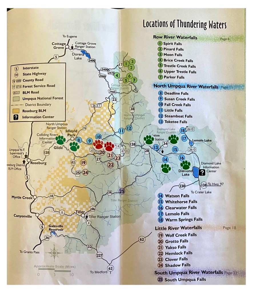
The Map below is Taken From the: “THUNDERING WATERS” Brochure available from the Roseburg Visitor’s Center, and North Umpqua Ranger Station – located next to Collidinging Rivers, and shows our stop at Colliding Rivers today, and waterfall stops over the next 2 days at: North Umpqua Waterfalls #13,14, 15 & 16, and Little River Waterfalls #20 and 21.

HWY 138/ROGUE UMPQUA SCENIC BYWAY

…the highway stretches in front of us…

…And, at 1:00 p.m., when we finally get out of our air conditioned cars, “Man Oh Man, is it Hot Out!” at:
COLLIDING RIVERS VIEWPOINT
(where the North Umpqua and
Little Rivers Collide)
…considered a geologic phenomena and only place in the US where this occurs

…quick, back in our cars…on to the next stop at:
THE NARROWS WAYSIDE
above the North Umpqua River

…with one last detour, taking a left off the 138w in Glide onto Little River Rd, a Right at Cavitt Creek to:
CAVITT CREEK COVERED BRIDGE
Built in 1943
over the LITTLE RIVER

…before driving back to check into our Roseburg Air BNB in the hills and home base for the next 3 nights.
What a Find!
Sunset from our deck


DAY 2, Tuesday, MAY 16, 2023 AIR BNB ROSEBURG, HWY 138, WHITHORSE, CLEARWATER, WATSON and TOKETEE FALLS, ROSEBURG
Today promises to be another warm day, as we head for the furthest of the North Umpqua Waterfalls/Scenic Highway High Cascades Segment, and work our way back, starting with #15 WHITEHORSE FALLS, #16 CLEARWATER FALLS, #14 WATSON FALLS, then #13 TOKETEE FALLS, in that order.
North Umpqua River Facts: is a tributary of the Umpqua River, flows nearly 100 miles from high in the Central Cascades to where it joins the Umpqua River near Roseburg, OR.
Note: All Waterfalls are well signed from the Hwy and have restroom facilities.
NO FEE OR PASS REQUIRED
WELCOME FLYNN!

The ROGUE UMPQUA SCENIC BYWAY/ 138E

…Our first stop on this Tuesday’s Waterfall Tour, is a 1.25 hour drive from Roseburg on the 138E to WHITEHORSE FALLS, where we take a left into the Campground, and find of all things, SNOW?…so decide to leave our cars parked at the entrance, and walk the short distance down into the campground…


….to find the accessible boardwalk and viewing platform for:
WHITEHORSE FALLS
elevation: 3,674’
15′ Punchbowl
on the Clearwater River
“X” Marks the Spot”

Then, just as we are set to leave, we run into a couple from Switzerland, who tell us about Clearwater Falls, “only a few miles/minutes away,” so we continue east on the 138, taking a right turn when we see the sign for Clearwater Falls, another left at the fork in the road, park, and walk the short 400′ on the accessible trail to the viewing platform for:
CLEARWATER FALLS
30′ Segmented Falls
on the Clearwater River
(Claim to Fame: known for it’s crystal clear waters)

..then we’re back on the 138 west, and 15 minutes later arrive at WATSON FALLS, My Dear (Ha, Ha,) turning left off of the 138 onto the 37, a right into the large parking lot…and begin our hike from here on the .8-mile WATSON FALLS Loop Trail, clockwise.
WATSON FALLS TRAIL MAP

WATSON FALLS
293′ Plunge Falls
on Watson Creek
(Claim to Fame: Highest waterfall in Southwest Oregon, 3rd highest waterfall in Oregon)
FOOTBRIDGE VIEWPOINT

Feel the Mist!

PAWTRIPPERS ARE US
Dana, Judy, Laura, Flynn Dog, Carole
@ UPPER VIEWPOINT


..Then back to the 138 west, and make our last, but not least stop at:
TOKETEE (Meaning “Pretty”) FALLS
on the North Umpqua River
plunging through Volcanic Basalt
2 Tier Falls
80′ Upper Falls, 40′ Lower Falls
.8 Mile RT hike
…here we go…
🎶”200 Stairs on the Toketee Trail,
200 Stairs on the Trail,
You take one down….
200 Stairs on the Trail!’
(Sung to the tune of “100 Bottles of Beer on the Wall’)

THE PAYOFF
🎶”If You’re HaPpY and You Know it then Your Face will surely Show It!”


And, Feast your eyes on our Wildflower Finds today on the Trails, and along the Highway!

It’s now time for All Good PAWTRIPPERs to head for the Roseburg hills, and:
ANOTHER SUNSET FROM OUR DECK

DAY 3, Wednesday, MAY 17, 2023 ROSEBURG, YAKSO FALLS, GROTTO FALLS, ROSEBURG
This morning we’re off to explore the LITTLE RIVER WATERFALLS, taking Hwy138E to Glide, a Right turn onto Little River Rd/17, Little River Rd/FS27 all the way to Lake-in-the-Woods Campground, and YAKSO FALLS TRAIL (#21 on Map,) then back to FS2703, a right turn, to a fork in the road, left, across the bridge, and GROTTO FALLS TRAIL (#20 on Map.)

Yes, We do eventually manage to find the unmarked trailhead to YAKSO FALLS (meaning there is no sign that says, “Yakso Falls” just a Hiker Symbol, ) located directly across the road from the Lake-in-the-Woods Campground entrance (as described in the literature,) and here begin our 1.4 RT hike, following the shaded trail that first climbs a short distance uphill, levels out, then gradually heads downhill, to where we walk around a large rock wall, are hit with a welcome blast of cold air, and behold, YAKSO FALLS!
Note: Parking for this trail is along the side of the road and there are bathrooms just inside the campground.
NO FEE OR PERMIT REQUIRED

YAKSO (“Hair of the Head”) FALLS
on the Little River
60′ Fan

…then it’s back to GROTTO FALLS, which we initially have trouble finding with the FS2703 sign facing the opposite direction, and Coolwater Campground Sign still covered for the season, but persevere, and eventually see the turnoff, follow the graded road up to where it forks, veer left at the Grotto Falls sign…

..drive across the bridge, park, and look for the trail sign, (another hiker symbol,) which we locate behind the outhouse, then follow the trail .25 miles uphill to:
GROTTO FALLS
on Emile Creek Tributary
100′ Plunge
(Claim to Fame: You can walk behind this Waterfall)
.5 RT Hike

 Today’s wildflower display

Our afternoon visit to the Little River Waterfalls comes to an end with a late picnic lunch at the Wolf Creek Picnic Area, before we return to our AIR BNB, to enjoy one last:
SUNSET

DAY 4, Thursday, MAY 18, 2023 ROSEBURG, ROGUE RIVER TRAIL, PARADISE LODGE
This morning we pack up, and are on our way to the remote PARADISE LODGE on the ROGUE RIVER, a 2-1/2 hour drive South of Roseburg, followed by a 3.8 mile hike.
Using GPS, we take the I-5 South to the 103/Riddle exit, then follow Cow Creek Road, taking a right onto West Fork Road, and here the fun begins, as we go from developed roads, to gravel, to dirt, 4-lanes, to 2, then 1, up hill and down dale, with a final questionable drive on the rugged, narrow Rogue River Trail? (this can’t be right?) to the good-sized Marial Trailhead Gravel Parking (phew!,) and starting point for our 3.8 mile hike above the ROGUE RIVER on the ROGUE RIVER TRAIL to PARADISE LODGE (that was certainly a mouthful.)
Cow Creek Road

ROGUE RIVER TRAIL MAPS BELOW:
6-7.6 RT Hike from Marial Trailhead to Paradise Lodge and back
This great Map was taken from William Sullivan’s ‘100 Hikes in Southern Oregon”


“And into the SISKIYOU NATIONAL FOREST we go
To find ourselves and lose our souls!”
(based on John Muir Quote)

It’s a SCORCHER, I mean PANTING HOT out for the FLYNN DOG, as we hit the trail at 2 p.m. hiking the Ledge above the Rogue River and Mule Canyon.
SPRING HAS SPRUNG
along the Rogue River Trail
WILDFLOWERS!…and lot’s of them
(Providing a welcome, if only a momentary, distraction from the heat!)


Walking on the LEDGE!
“Don’t Look Down, It’s a CLIFFHANGER!”


STAIR CREEK FALLS
(across the river)
Photo taken on the Trail from Inspiration Point
Double Punchbowl
40′-60′ Falls

Finally, 4 Hours and 3.8 miles later…
At Last! At Last!
PARADISE LODGE FOUND!
…An Oasis in this Forsaken Heat

“Never Fear, FLYNN is Here!”

“Check it Out DOGS!”

“Time For Some Refreshment”
 “Belly Up To The BAR”

CREATURE COMFORTS!
Our Dog-Friendly Cabins
The General & Eagles Nest
with flush toilets, electricity & showers to boot, OH BOY!

@ 7:00 p.m. the Lodge Dinner Bell Rings for FAMILY-STYLE DINING.
(Note: Family-Style Dinner, Breakfast, and a Sack Lunch are included with stay)
“FLYNN BRECK PARTY OF 5”
 …after a long, but rewarding day, Nighttime commeth, and, we’re 🎶”Off to rest, off to rest” with a gentle breeze blowing through our cabin windows, listening to the whispering waters of the Rogue as they lull us to sleep…🎶”…and may sweet be thy dreaming”…Zzzz!
DAY 5, Friday, MAY 19, 2023 PARADISE LODGE, ROGUE RIVER TRAIL, LAKE OSWEGO
A Real rooster crows this a.m. at 5:30 a.m., and our last day in Paradise begins, sitting outside the lodge watching the world go by until the Breakfast Bell Rings @ 7:00 am:
Breakfast of Hikers
What a Feast!

At 9:30 a.m., we’re fueled up and ready one last time, for the Trail back to our cars…”Second verse, same as the first, a little bit warmer and a little bit worse!”
View from the Trail
Kayaker Below (a mere speck on the water) &
STAIR CREEK FALLS Ahead

TRAIL CHIQUE
“FLYNN is wearing the latest in Trail Fashion, Sporting a Cooling Buff,
and Boots, a must have for any dog hiking the Rogue River Trail!”
(Note to Dog Self: Should have worn the Cooling Vest too!)

…and, of course, there are even more:
WILDFLOWERS


When we arrive back at our cars, (which oddly enough have stayed cool in the shade,) we load our gear, then start the long trek back the way we came (with No GPS/Cell Service this time,) through the Woods (Forest) to Cow Creek Road to town of Riddle, where we fill our tanks, then it’s out to the I-5 North, and Home…While Visions of WATERFALLS, WILDFLOWERS AND PARADISE Dance in our Heads.
“THAT’S ALL FOLKS,”
Until Next Pawtrip…
“Of all the paths you take in life,
make sure a few of them are dirt!”
– John Muir
ITINERARY AT A GLANCE
(see above maps and links for additional information)
DAY 1 Monday – Lake Oswego, OR to Colliding Rivers,
- From Lake Oswego, OR, I-5 South to Hwy 138E/Rogue Umpqua Scenic Byway
- COLLIDING RIVERS – 18782 N. Umpqua Highway/138, Glide, OR
- Then continuing 5 miles east and rt to
- THE NARROWS WAYSIDE
- 138 west to Glide, OR, left on Little River Rd., Right on Cavitt Creek Rd.
- CAVITT CREEK COVERED BRIDGE
- Hwy 138W to Roseburg, OR
- AIR BNB – Roseburg, OR Hills
DAY 2 Tuesday – Roseburg Air BnB, Whitehorse Falls, Clearwater Falls, Watson Falls, Toketee Falls, Roseburg Air BnB
- From Roseburg Air BnB, Hwy 138E 66 miles and left into Campground &
- WHITEHORSE FALLS – Idleyld Park, OR
- 138E 6 miles and rt to
- CLEARWATER FALLS
- 138W 9.5 miles, left on NF37 .2 miles to
- WATSON FALLS
- 138W 2.8 miles to
- TOKETEE FALLS
- 138W TO ROSEBURG AIR BnB
DAY 3 Wednesday – Roseburg Air BnB, Yakso Falls, Grotto Falls, Roseburg Air BnB
- From Roseburg Air BnB, Hwy 138E to Glide, OR, a Rt turn onto Little River Rd/17, a left onto the Little River Rd/NF27 all the way to Lake-in-the-Woods Campground.
- YAKSO FALLS – trailhead is across the road from Lake-in-the-Woods Campground Entrance
- 27 to NF2703 rt. (across from Coolwater Campground), to where the road forks and sign points left to Grotto Falls, across the bridge and park.
- GROTTO FALLS – (trail starts behind outhouse)
- Little River Rd, back to 138W to
- ROSEBURG AIR BnB
DAY 4 Thursday – Roseburg Air BnB, Rogue River Trail, Paradise Lodge
- From Roseburg Air BnB, I-5S to Riddle/Exit 103 – 23 miles
- Reuben Rd/Cow Creek Rd., rt onto West Fork Rd., left onto Mule-Creek Marial Rd
- Continue on Marial Rd, past Marial Lodge, stay right onto Rogue River Dirt Trail and follow to Gravel Parking and Marial Trailhead.
- Follow ROGUE RIVER TRAIL 3.8 Miles above Mule Canyon and Rogue River to
- PARADISE LODGE – Agness, OR (Room rate pp based on double occupancy, includes Family Style Dinner, Breakfast and sack lunch, there is a refundable Pet Fee (check or cash) which you give to Managers at check in)
DAY 5 Friday – Paradise Lodge, LakeI Oswego, OR
- PARADISE LODGE back the way we came to RIDDLE
- I-5 North to Lake Oswego, OR
RESOURCES
TRAVEL OREGON
EXPERIENCE ROSEBURG
BLM ROGUE RIVER GUIDE & MAP
PINTEREST- Various Blogs
ROGUE-SISKIYOU NATIONAL FOREST
UMPQUA NATIONAL FOREST
AIR BNB
PARADISE LODGE
THAT OREGON LIFE
ONLY IN OREGON
ALLTRAILS
OREGON HIKERS
TRIPCHECK
OUTDOOR PROJECT
“100 HIKES IN SOUTHERN OREGON” – William Sullivan
“WATERFALL LOVER’s GUIDE TO THE PACIFIC NORTHWEST” – Gregory Plumb
”OREGON ROAD AND RECREATION ATLAS”
”THUNDERING WATERS” Brochure
‘ROGUE-UMPQUA NATIONAL SCENICE BYWAY Brochure (picked up at FS Office)
THE OREGONIAN “Day Hiking the Spectacular Rogue River Trail” – Jamie Hale
PACIFIC NORTHWEST WILDFLOWERS
PictureThis APP
FLYNN’S PACKING LIST
Dog Food
Paw Butter
Mushers Secret
Dog Goggles
Towel
Toys
Dog Treats
Brush
Dog Bowls
Dog Treats
Sheet
Travel Dog Bed
Dog First Aid Kit
Bottled Water
Vest
Dog Boots
Leash
Dog Waste Bags
Safety Harness
Dog Cooling Vest
Dog Cooling Buff
Leash
Dog Waste Bags
Safety Harness
Tick Comb
Window Shade for backseat windows
Dog Waste Vault (DIY from empty Tub-O-Towels container)
A delight filled adventure created and curated by Carole Breck! You brought me with you on this pictoral journey. Thank you!